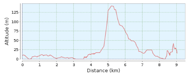
Hiking route Cala Bona Canyamel

Distance 9.6 Km.
Duration 150 min.
Ascending slope 250 m.
Difficulty 3/4
Type no circular
From Cala Bona Tourist Information Office follow the cycle track in the direction of Costa dels Pins.
When the cycle track ends continue straight on towards Costa dels Pins. Pass Sa Marjal beach and continue until you come to Avinguda del Pinar. Keep straight on until you come to Plaça Donants, where you will see a stone monument. From there take Carrer Romaní on the left of the roundabout and after about 300 metres, on your left you come to a path, which you follow until you reach a metal fence and a revolving gate. From here take the path that runs alongside the Son Servera golf course. After 800 metres it turns to the left and after another 800 metres you turn to the right passing below the high voltage power lines and take the path that leads to El Coll Baix from where you have fantastic panoramic views of the coast. The summit is about 250 metres high. At this point you come to a barrier at the start of a forest track that descends towards Canyamel. On the way down you come to a square platform with a fence and a potable water well; turn right, towards the south-east, along a path that after a few minutes takes you to the Canyamel road. Turn left and you will soon come to Canyamel.
At this point you come to a barrier at the start of a forest track that descends towards Canyamel. On the way down you come to a square platform with a fence and a potable water well; turn right, towards the south-east, along a path that after a few minutes takes you to the Canyamel road. Turn left and you will soon come to Canyamel.
Once there you can visit the famous Artà Caves.
Places of interest:
Sa Marjal beach
Golf Club (Costa dels Pins)
Artà Caves (Canyamel)
Canyamel Wetlands Interpretation Centre
